Overview
Causes, impacts and patterns of disastrous river floods (Nat. Rev. Earth Environ.
A detailed review paper which discusses causative factors trigerring extreme floods, including atmospheric drivers (from near-term to long-term), antecedent conditions (soils and groundwater), subsurface contributions, river networks, land-use changes, anthporogenic alterations (straightening/deepning channels or retention measures).
In addition, flood impacts are discussed towards socio-ecnomic hydrology.
Understanding flood regime changes in Europe HESS
This paper reviewed the flood regime - The flood discharges of a catchment, their exceedance probabilities and their seasonality are collectively termed “flood regime” in this paper - with respect to three main drivers: river, catchments, and atmosphere.

They also laid out some mainstream approaches to investigate flood regime changes.


Extreme flooding controlled by stream network organization and flow regime Nat Geoscience
The authors determined how static catchment attributes determine flood divides which is a threshold to discriminate normal flooding or major flooding.
- The spatial organization of stream networks and the river flow regime control the appearance of flood divides and extreme floods.
- The propensity to generate extreme floods is well predicted by intrinsic properties of river basins.
- It can be assessed prior to the occurrence of catastrophes through measurable metrics of these properties derived from commonly available discharge data, namely the hydrograph recession exponent and the coefficient of variation of daily flows.
- Flood divides are effective attributes to distinguish common from increasingly extreme floods that may occur in river basins.
- The existence and magnitude of the flood divide represent pivotal features to characterize the propensity of rivers to extreme hydrological events and raise awareness of the intrinsic peril of floods in these contexts.
The Pakistan Flood of August 2022: Causes and Implications Earths Future
- The August 2022 Pakistan flood was caused by multiday extreme precipitation on wet antecedent soil moisture conditions
- The extreme precipitation in August was caused by two atmospheric rivers that passed over southern Pakistan.
- The southern provinces of Pakistan received more than 350% of average precipitation in July and August based on the 2001–2021 mean.
- The flood event is ranked second in human mortality and displaced about 33 million people in Pakistan.
- The frequency of extreme weather events has considerably increased across the globe under the warming climate.
- The impact of extreme events is unarguably the highest in the developing countries of South Asia due to higher vulnerability and exposure.

Terrain
The Need for a High-Accuracy, Open-Access Global DEM
In this paper, the authors investigated the geomorphological impact on flood duration, peak, and volume based on a bayesian framework that used to scaling thos geomorphological factors to targets. They used a hierarchical clustering analysis to isolate regions with high dependence on each of those factors.
Canopy interception
Canopy precipitation interception in urban forests in relation to stand structure
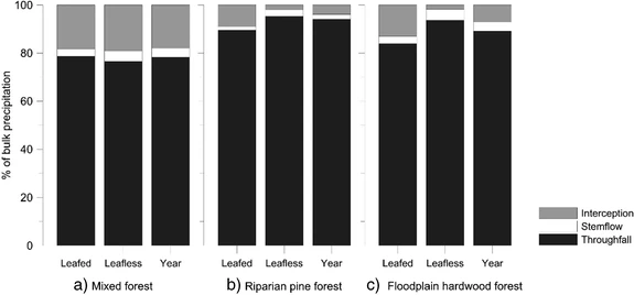
In this paper, the authors split bulk precipitation into throughfall, stemfall, and canopy interception with gauged observations. They evaluated compositions of each during leafness and leafed period for three types of forests: mixed forest, riparian pine forest, and floodplain hardwood forest.
The composition is shown as below where in Leafed period and mixed forest, the interception could take up over 20% of the total precipitation.
Evaluation of canopy interception schemes in land surface models
Canopy interception is evaluated with Land surface models, in which the authors proposed a scheme that differentiates rain type (convective or straitiform).
They claimed that the global average interception loss is around 0.31 for 60-min resolution, concentrated on rain forests, but even higher for 20-min resolution. convective storm will have higher positive impact on interception loss.
Soil/Infiltration
Estimating dominant runoff modes across the conterminous United States
In this paper, the authors classified US into their dominant hydrologic processes: 1) infiltration-excess flow and 2) suturation-excess flow.
“Infiltration‐excess processes (hereafter referred to as IE) follow from precipitation intensities that exceed soil permeability, for example, in places with soils having high clay content, compaction, or impervious surfaces. Conversely, saturation‐excess runoff (hereafter referred to as SE) is more likely in regions where infiltration capacity exceeds precipitation, for example, in places which have humid, well‐vegetated, and low‐lying areas where surface and subsurface flows converge. For instance, where and when SE dominates, a topographic wetness index can effectively depict fine‐scale spatial moisture patterns by revealing variable runoff source areas with lower gradients and greater contributing areas”
“The intensity or likelihood of IE runoff, as indicated by the degree to which 1‐hr storm depths exceed representative surficial KSAT, is the greatest in portions of Texas, Louisiana, Kansas, Missouri, Iowa, Nebraska, and Western South Dakota. SE runoff, on the other hand, is more likely in Florida, Southern Georgia, Southeastern California, and Nevada, as well as western Oregon and coastal areas of the Great Lakes region”
A CONUS-wide Ksat exceedance is provided as follows:

In this paper, the authors comprehensively investigated the significance of run-on infiltration for WRF-Hydro. A few model parameters are cross-correlated with reinfiltration ratio (defined as reinfiltration / total infiltration).
Soil Moisture Responses to Rainfall: Implications for Runoff Generation WRR
In this paper, the authors intend to investigate the storm impact on soil moisture in not only vertical direction but also lateral flow in hillslopes driven by preferential flow etc using field measurements. They address (1) how do soil moisture responses to storms vary spatiallly and temporally, (2) what are the controls on these responses? (3) what factors influence relationship between runoff and soil moisture responses?
They showed in nearly 40% of storms, soil moisture peaked earlier to runoff, indicating potential subsurface contributions from hillslopes to runoff at outlet.
Should flood regimes change in a warming climate? The role of antecedent moisture conditions GRL
The authors claim that antecedent soil moisture is a main driver that explains the decreasing trend in floods in some continents. They used the Antecedent Precipitation Index to approximate antecedent soil moisture using global rain gauges.
Groundwater
Groundwater shapes North American river floods ERL
This article stresses the importance of groundwater (or other antecedent catchment wetness) to flood generating by using gauged streamflow and other hydrometeorological variables.
Key takeaways are:
- Baseflow affects the magnitude of annual flooding at time scales from days to decades
- Flood magnitudes are often more strongly correlated to variations in antecedent basedflow than antecedent soil moisture and short-term extreme precipitation
- Groundwater is important in shaping North American river floods and often decouples the spatial patterns of flood trends from those of shifting precipitation extremes and soil moisture.
Urbanization
Zhou, Z., J. A. Smith, L. Yang, M. L. Baeck, M. Chaney, M.-C. Ten Veldhuis, H. Deng, and S. Liu (2017), The complexities of urban flood response: Flood frequency analyses for the Charlotte metropolitan region, Water Resour. Res., 53, 7401–7425, doi:10.1002/2016WR019997.
In this paper, the authors examined the urban flood characteristics in Charlotte metropolitan area. They addressed basin attributes, stationarity, flood agents, the attributes of antecedent rainfall (wettness) to urban floods, flood response time, runoff ratio to drainage area, correlation of basin-average rainfall to runoff, etc.
The methodlogies in flood analysis could be adopted and some of the conclusions could be cited as well.
The impact of urban development on hydrologic regime from catchment to basin scales
In this paper, the authors evaluated the flood magnitude, frequency, travel times on which the urbanization would impact. They designed experiments determining the spatial variability of impervious areas. Before that, they cautiously divided total impervious area by effective or non-effective impervious area to discriminate the different response by fitting a statistical method.
“This analysis supports the suggestion that the impact of urbanization on flood magnitude decreases as flood recurrence intervals increases as was found by Hollis (1975).”
“watersheds with urban land use located close to the outlet tend to produce smaller peak flows than ones with urban land uses located far from the outlet for the same storm events.”
“restricting infiltration rate does not have much impact on high flows during the snow melt season if urban area was located near the basin outlet”
“It demonstrates that antecedent soil moisture could play an important role in assessing the impact of urbanization on flood peaks”
The Regional Hydrology of Extreme Floods in an Urbanizing Drainage Basin by Smith et al. 2001
The authors characterize the response time (V/P) by the flow volume (V) that is calculated as the integral of flows 1 day prior to the peak flow and 2 days after divided by the flow rate (P).
They investigated the impact due to land cover properties interms of flood magnitude and flood response time; antecedent soil conditions play an important role; the spatial variability of rainfall affects the flood response; storm structure and motion also has marked impact.
Beyond imperviousness: the role of antecedent wetness in runoff generation in urbanized catchments
In this article, the authors attempt to examine the interplay of imperviousness and antecedent soil moisture to runoff generation in the US with a large samples.
They considered a range of climate variables and land use variables and morphology variables and geopedology variables. Storm event separation is discussed in this methodology
Causal Effect of Impervious Cover on Annual Flood Magnitude for the United States
In this work, authors adopts causual inference on flood magnitude changes due to the increase in imperviousness. They concluded that one percent increase in impervious basin cover causes a 3.3% increase in annual flood magnitude in the US.
They summarized main three approaches to study on this topic:
1) Case study focusing on temporal variations.
2) paired catchment with contrast experiment variable.
3) Model simulations.
Manmade structure
In their introduction, they mentioned two factors playing important role in flood inundation mapping:
-
Detention infrastructure can play an important role in storing runoff and lowering flood peaks in urban watersheds. Past modeling work found that detention infrastructure could lower a single event peak discharge by 48–50% for the small 1–2 km subbasins within Dead Run [Meierdiercks et al., 2010aa]. However, modeling efforts in larger 5.5 km2 and 62 km2 watersheds have suggested that detention basins could potentially increase outlet peak discharges slightly by delaying the timing of the peak responses in downstream portions of the drainage network and aligning them with peak discharges from upstream portions of the drainage network [McCuen, 1979; Emerson et al., 2005].
-
Another major source of storage in urban watersheds is within the soil column. Even highly urbanized watersheds frequently have as much pervious cover as impervious. It would be a mistake to ignore the important role that infiltration can play in the flood response of urban watersheds.
They designed two experiments to tackle these two issues: they replaced detection rating-curve with streamflow rating-curve to simulate detention-free scenario; they replaced upper soil layer parameters with lower layer parameters to simulate less compaction scenario. Soil storage is further investigated by giving an uniform soil type (silt) and hydraulic conductivity throughout the catchment.
The authors routed streamflow using RAPID and output flood inundation using AutoRoute after nudging observed reservoir release to model output. They found a significant improvement regarding flow metrics with incorporating reservoir module.
Atmosphere
Key Factors Influencing the Severity of Fluvial Flood Hazard from Tropical Cyclones
In this paper, they investigated some determining factors related to Tropical Cyclones that potentially influence the flood severity (factored by area, magnitude, and duration) using the GloFAS-ERA5 framework.
- Intensity - pressure and wind speed:
- Translation speed - forward motion speed: clearly severe floods occur by slow-moving storms
- Size and shape:
- Precipitation: total precipitation presents the most influential impact factor.
- Antecedent soil moisture: more saturated antecedent soil conditions tend to have greater flood severity while duration and magnitude are negatively correlated
- Orography and gradient:

the authors innovatively investigated the contributions of TC to streamflow, given most of the studies focusing on TC to precipitation or other atmospheric factors. This study helps to understand the main atmospheric driver for regional flooding.
As a result, TC account for 12% of seasonal streamflow and 6% of seasonal precipitation. TC constitudes over 10% of the Peak-Over-Threshold events.
The authors used the event storm reports to link flood events with MCS clusters identified using a tracking algorithm. It is found that clustered MCS not only producing greater rainfall volumes that are conducive for flooding, but also moisten soils that generate greater surface runoff than non-clustered MCSs. It is also found that flood durations are closely related to the clustered MCSs.

This was written by Ruby Leung in 2006. This study investigates how atmospheric rivers compounded with different antecedent land surface conditions can exacerbate flood conditions on the West Coast. It uses a 20-year WRF simulation in tandem with event-based analysis.
“For precipitation to generate floods, our results underscore the important role of antecedent soil moisture, as well as precipitation phase (or snow level), which depends on temperature, and possibly melting of existing snowpack due to rain-on-snow. For a climate simulation to realistically characterize extreme precipitation and flood in the western U.S., the model must be able to simulate AR and its atmospheric structures, as well as the land surface conditions. “
Climate Change
Continental‑scale convection‑permitting modeling of the current and future climate of North America
Physical downscaling of global climate model with convection-permitting feature, which can be used as input to investigate the impact of climate change on fine-scale hydrologic responses.
Changes in Future Flash Flood–Producing Storms in the United States
The authors adopted datasets from Dr. Liu for 13-year convective-permitting model and coupled with Noah-MP community model to investigate the flood (i.e., flash flood) response due to a warming climate. They compared CRTL and PWG precipitation against NCEP stage IV dataset using the SSMI index to investigate the structural similarity. But not much traditional quantification has been done. Without any doubts, climate change changes the frequency of flash flood and rainfall intensity. 7.5%/K increase in hourly max. rain rates is observed, but medium rain rates are on par with Clausius-Clapeyron theory.
In this article, the authors seek to investigate flood risks based on a host of environmental variables, including hydrometrological, topographic, and geological factors. Climate change is factored based on statistical downscaling from long series of gauge data for the change of precipitation, and ANN based methods take account the landuse changes. It is insightful to consider the varibles that could affect flood risks.
In this article, the authors pointed out three approaches to investigate the climate change impact on flooding. (1) Assuming stationarity, (2) hydrologic simulation under general circulation models, and (3) informed-parameter (e.g., time or trend analysis, climate indices, infrastructure development indices, land use indices.They also reviewed lots of literatures and found their limitations.
They specifically look at several questions: (1) how does out-of-sample bias compare between stationary assumption and other approaches, (2) can the direction of change at a gage be projected?, (3) can regional change be projected?, and (4) how much additional bias is introduced when GCM outputs are used to force the climate-based approaches.
In methodology, they first regionalize US basins with self-organising approach, and measured by sihouette width and physical meaning. Then they compared stationarity, climate-informed, precipitation-informed, and hydrologic simulation under the context of Bayesion inference. To conclude, they found precipitation and hydrologic simulation are statstically significant to reveal the flood projection.
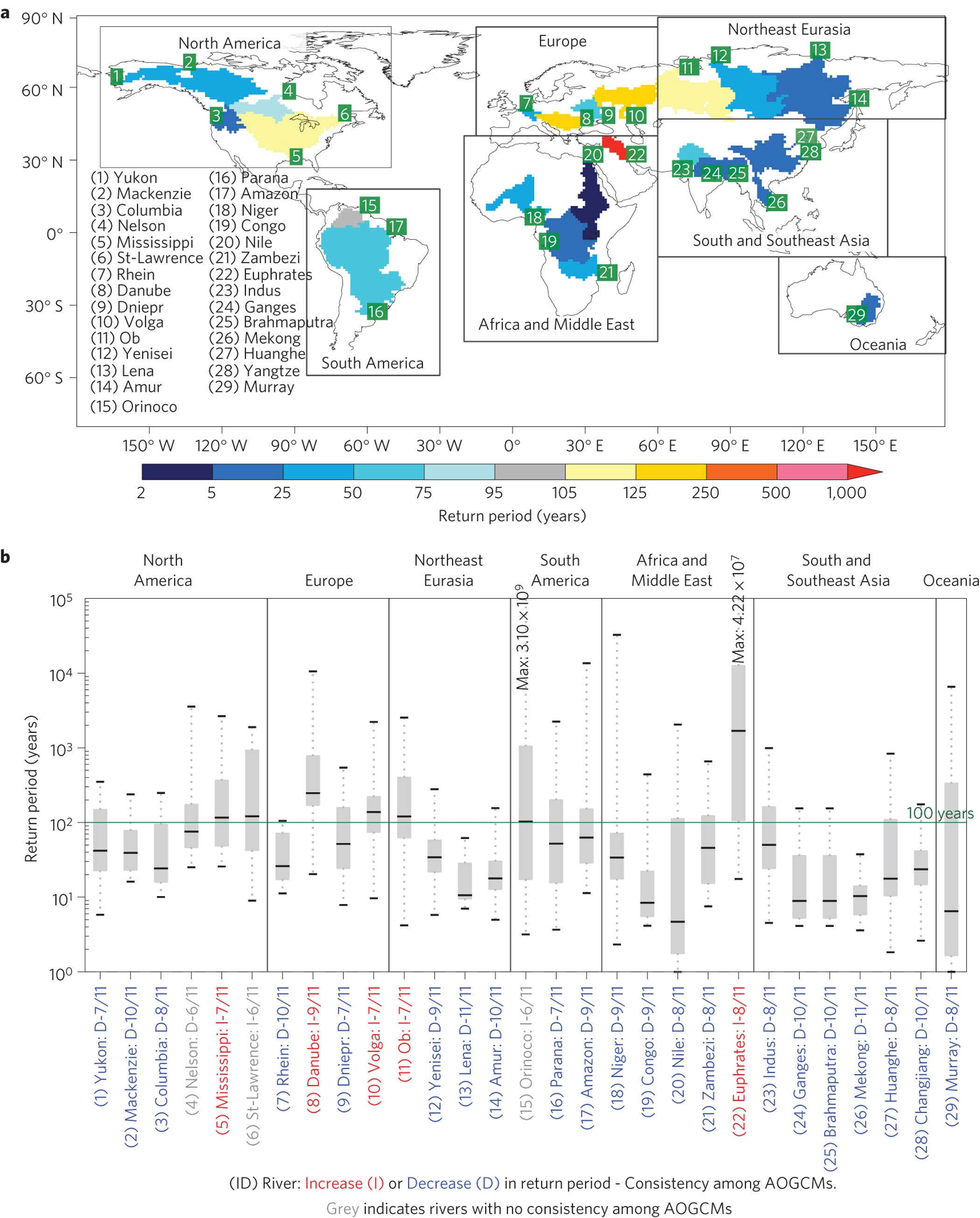
Global flood risk under climate change
This paper published in Nature climate change is one of the highly reputed articles that studied flood intensity/frequency changes under a warming climate. It classifies major global river basins and finds a heterogenous feature for future flood response as below. They also simulated number of impacted and exposed people in a future scenario.
Future projections of flood dynamics in the Vietnamese Mekong Delta
In this paper, the authors collectively evaluated the change of flood dynamics under the impact of climate change, hydropower regulation, sea-level rise, sustainable development, and floodplain restoration. They not only quantitatively assessed flood hazards (inundation extent, depth, and duration), but also focused on impacts, specifically on rice damages.
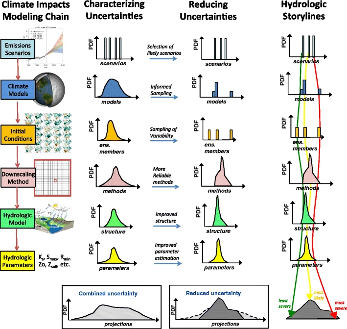
Characterizing Uncertainty of the Hydrologic Impacts of Climate Change
This paper, Clark et al. reviewed the uncertainties inherent to climate-driven hydrologic studies from different perspectives as shown in the figure below.
Going beyond the ensemble mean: assessment of future floods from global multi‐models
the authors discussed the advantages of using multi-model ensembles to replace “one-model-one-vote” approach.
“There is indeed a growing interest in the scientific community dealing with climate impact studies on the opportunity of going beyond the ‘one-model onevote approach’ (or “model democracy” (Knutti, 2010)) and favouring model runs with a better historical performance in reproducing observations with the aim to reduce uncertainty”
In peak flow distributions, the authors assessed the time series with three tests: 1) same distribution (KS test), 2) equal median (Wilcoxon rank-sum), and 3) equal variance (Ansari-Bradley).
Flood timing shifts are also investigated in this study, pointing to a general conclusion of earlier peaking time.
Interestingly, they found flood magnitude for all models indicates a genearl decrease in future over southeast U.S. These features are explained by two-fold: 1) uncertainties due to representation of precipitation and sub-grid soil infiltration; 2) total runoff contributions from saturation excess flow and infiltration excess flow.
“If on the one hand GCMs are responsible for regional runoff biases due to uncertainties in the representation of precipitation and sub-grid soil infiltration and flow; on the other hand the GIMs’ total runoff include contributions from surface runoff – function of saturation and infiltration excess – and subsurface runoff – function of impermeable area and water table depth”
“The prevalence of infiltration (IE) or saturation (SE) excess runoff depends on the type of soil and its capacity to become saturated / infiltrate. A sandy soil in the southeast will yield a higher flux (i.e., will transmit water faster) than a clayey soil under a given hydraulic gradient, reducing the effects of high-intensity precipitation.”
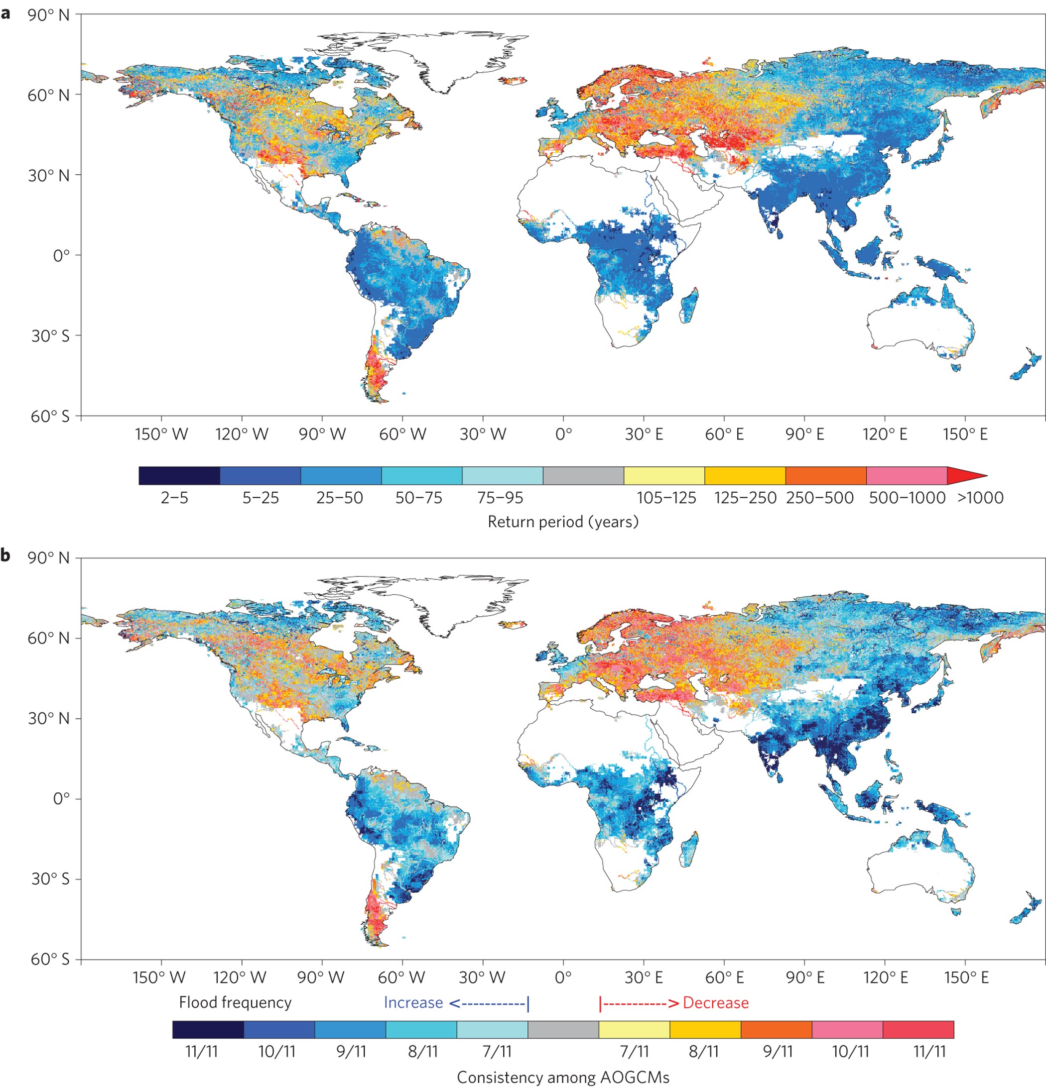
Global Changes in 20‐Year, 50‐Year, and 100‐Year River Floods
In this paper, the authors emphasized the non-stationarity when constructing GEV. They extracted hundreads of years of streamflow globally, and classified based on Koppen-Geiger climate regimes.
For the 20‐ and 50‐year return periods, we find a majority of increasing floods in temperate climate zones, but a majority of decreasing floods in arid, tropical, polar, and cold climate zones. For the 100‐year return periods (a smaller sample of sites with at least 70 years of data), we obtain slightly different results, with decreases in arid and temperate zones; mixed trends in cold zones; and increases at a small sample of tropical sites.
Future streamflow regime changes in the United States: assessment using functional classification
The authors considered the temporal evolution of hydrologic regimes in current and future climate simulations. They simulated discrete time series of flow rate from ~600 US catchments from the VIC model to interpret how the hydrologic regimes will change at daily scale.
In doing so, they project discrete flow rate onto a basis function (B-spine) with tunable parameters for each catchment. Then, they used a hierarchical clustering algorithm which allows for non-elliptical clusters, minimizing the total within-cluster variance.
One take from this project is that they not only limited by traditional evaluations, which is computation of KGE or Nash, but they also considered evaluations on catchment characteristics. For instance, regimes with intermittent flow are characterised by weak seasonality.
Regime shifts turn out to only affect currently intermittent, strong winter, and NewYear’s regimes. Currently intermittent regimes are mostly changing to weak winter regimes, currently weak winter regimes to intermittent or strong winter regimes, and currently strong winter regimes to weak winter or New Year’s regimes, regime types relatively close to their current regime.
Geographically, regime changes are expected according to most GCMs in the Rocky and Appalachian Mountains and to a lesser degree in the Pacific Northwest and the Midwest. In contrast, regimes of catchments in the Great Plains are predicted to be mostly unaffected by changes.
Increases in temperature do not translate to increased flooding
In this paper, the authors fights back to a common opinion that increase in temperature “euqal” to increase in flooding. They pointed out the study by Yin et al. using flood frequency analysis lack of evidence because it is not associated with rainfall events. In addition, they argue the definition for flash flood used in their paper is not appropriate. They argue for extreme streamflow, it is most likely modulated by preceding soil moisture condition.
This study attempts to affirm that “heavy precipitation does not necessarily lead to high stream discharge”.
Influence of changes in rainfall and soil moisture on trends in flooding
This study, authors emphysized the importance of soil modulating in floods, and it cannot be neglected in flood studies.
“smaller catchments are less sensitive to changes in antecedent moisture with larger rainfalls (and hence floods) less likely to be influenced by soil moisture storage”

Ambitious partnership needed for reliable climate prediction NCC
The authors call kilometer-scale climate projection datta to capture convective precipitation and empower disaster-related studies.
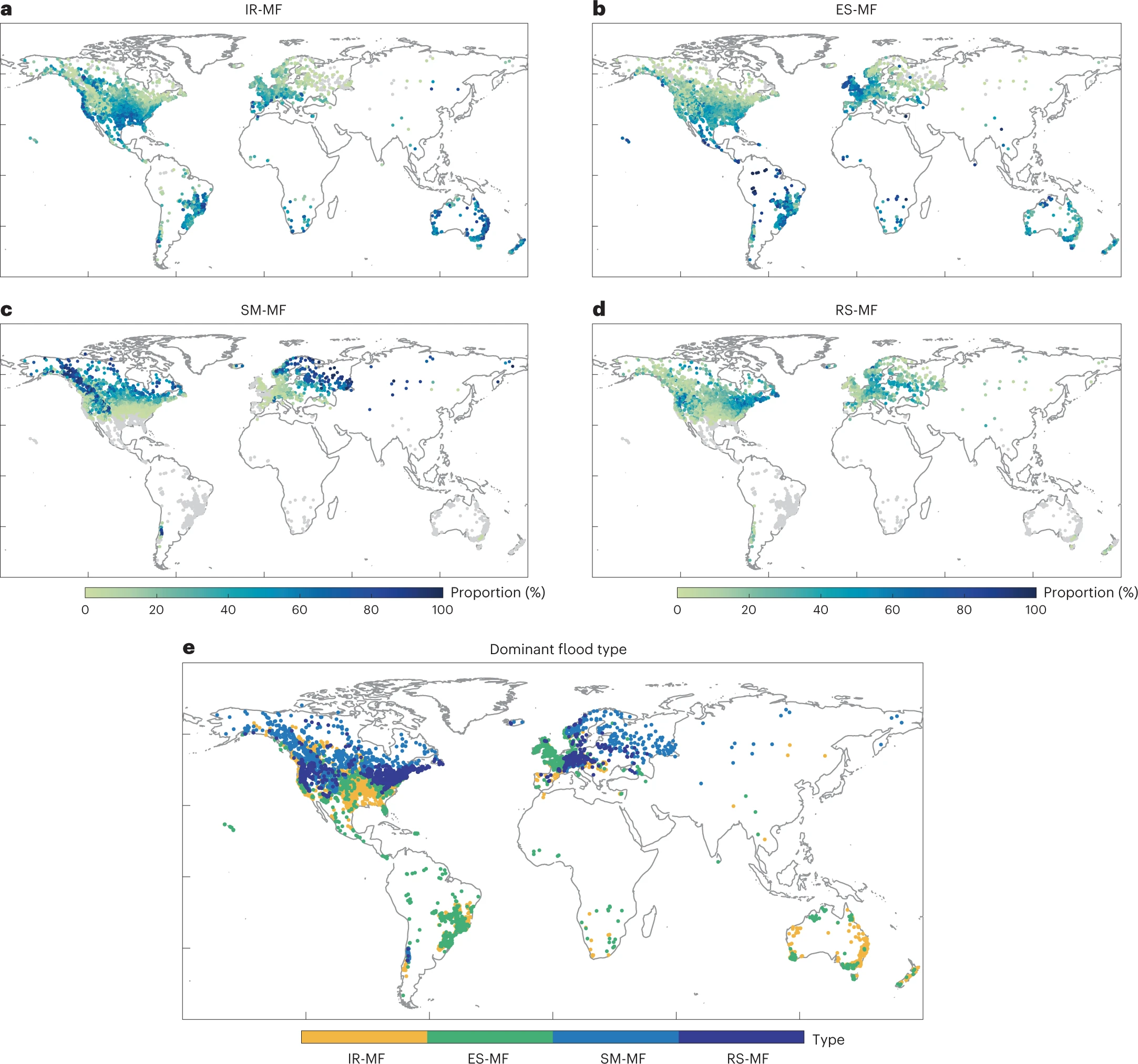
Reconciling disagreement on global river flood changes in a warming climate NCC This paper answers the call “If temperature increases, why not floods?”. In literature, there are abundant evidances that model shows widespread increases in flood severity and spatial scales, which contradicts observations showing decrease in flood frequency and occurrences. Therefore, the novelty of this paper is to classify different flood-generating mechanisms: excess rainfall, snow-melting, soil saturation, etc. In doing so, they found, snow-driven floods will decrease in the future, while excess rainfall-driven floods will increase.
A companion comment paper is also published in NCC Floods differ in a warmer future
This paper projects future EU floods under three warming levels based on five CMIP5 models and three hydrologic models. They quantified the contribution of uncertainties due to GCM and HM. It was found that for flooding, significant of uncertainties lie in HMs, suprisingly. Mostly high flows are reducing as the warming level increases in most EU.
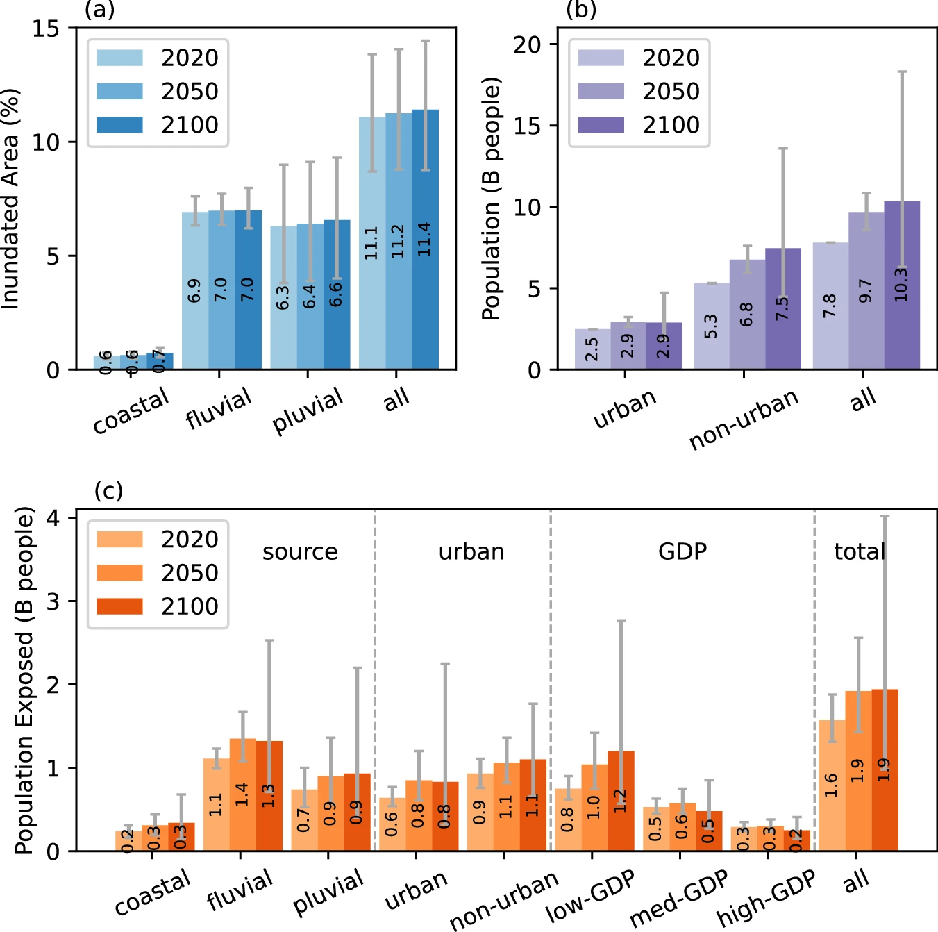
The role of climate and population change in global flood exposure and vulnerability NC
The author used a global flood model to predict changes in 100-yr floods using different sources: pluvial, fluvial, and coastal floods. They overlay that with socioeconomics to show flood exposures to people and under different land cover such as urban and non-urban.
Regional
An extremeness threshold determines the regional response of floods to changes in rainfall extremes
In this article, authors coupled a hydrologic model with SMILE (Single Model Initial-condition Large Ensembles) to investigate the impact of climate change to precipitation extremes and flood extremes in Switzerland and Germany. They found although the mean precipitation and flood magnitudes decrease in a warmer climate, extreme values (defined as 10-year, 20-year, 50-year, 100-year return) will change positively, especially for precipitation.
Spatial Attribution of Declining Colorado River Streamflow under Future Warming JH
This paper explains the decline in Colorado River Streamflow because of the decrease in snowmelt. One figure that could be insightful is the perceptual Figure shown below.

Climate change + Flash flood review
| Title | Journal | Climate Model | Flood model | Domain |
|---|---|---|---|---|
| Assessment of future flash flood inundations in coastal regions under climate change scenarios—A case study of Hadahe River basin in northeastern China | Science of Total Environment | NASA downscaled climate output (0.25-deg/daily) | FLO-2D | Regional (25m) |
| Projection of changes in flash flood occurrence under climate change at tourist attractions | Journal of Hydrology | NASA downscaled climate output + weather rainfall generator | NA (rainfall threshold) | regional |