Rainfall-runoff coefficient
Miao, C., Zheng, H., Jiao, J., Feng, X., Duan, Q., & Mpofu, E. (2020). The changing relationship between rainfall and surface runoff on the Loess Plateau, China. Journal of Geophysical Research: Atmospheres, 125, e2019JD032053. https://doi.org/10.1029/2019JD032053
In this article, authors examined the rainfall-runoff generation, particularly the coefficient changes over two periods: 1971-1987, and 2008-2016; This is a decent article to look or review possible attributes of the changing runoff in this specific region (i.e., human activity, vegetation, climatology etc.)
One adoptable methodology in this study is to determine the critical point for thresholding runoff throughout Pettitt test.
Main findings:
- The runoff coefficient decreased greatly in Loess Plateau;
- The precipitation threshold became greater on the middle regions of the plateau during P2.
Conceptual planetary hydrology
Gleeson, T., Wang‐Erlandsson, L., Porkka, M., Zipper, S. C., Jaramillo, F., Gerten, D., et al ( 2020). Illuminating water cycle modifications and Earth system resilience in the Anthropocene. Water Resources Research, 56, e2019WR024957. https://doi.org/10.1029/2019WR024957
In this big paper, the authors proposed a framework to address the scientific problems: How to determine the tipping point of changes resulting in a irreversiable situation; in other words, what is the maximum changes that breaks the earth system resilience.
Even though this is a conceptual paper, it really motivates researchers to dive into and look for answers to benefit our human society.
Tracking the weight of Hurricane Harvey’s stormwater using GPS data Sci Adv.
The authors showed how to use GPS data as a vertical displacement to estimate terristrial water storage changes during Hurricane Harvey event. They proposed a way to invert modeling to derive surface water and ground water by closing the water budget.

Sensitivity Analysis
Sensitivity analysis of environmental models: A systematic review with practical workflow
In this paper, authors comprehensively reviewed approaches to evaluate the sensitivity issue in environmental modeling, spaning from mapping, rakning, screening purposes and local/global sensitivity. A suit of methodologies such as pertubations, density, correlations are exclusively mentioned.
At the end, they proposed a workflow to dissect the sensitivity from inputs sampling to output post-analysis.
In this paper, the authors described a way to approximate the simplified 1D-Saint-Venant routing (aka. kinematic wave model) parameters by using historical USGS stream gauge data that links flow rate and depth (i.e., routing curve) and hydroclimatologic data (i.e., precipitation, soil moisture), and terrain (DEM).
This approach has been applied in the CONUS in the rencent 10 years with event-based studies. A satisfactory result has been produced by measuring the flood timing error and flood peak error.
Hodges (2013) suggested simplified routing methods should be increasingly substituted by hydrodynamic methods in large-scale hydrological models.
river routing and inundation dynamics are processes that, normally, are represented by relatively simple approaches. A recent review of twelve large-scale hydrological models (Kauffeldt et al., 2016) concluded that most of them use kinematic wave or even simpler methods for river flow routing. Huang et al. (2016) tested nine hydrological models in large-scale river basins, four of them not included in the review by Kauffeldt et al. (2016), and all of them have simplified methods for river routing.
In steep terrain regions, adopting simplified river routing methods is not often a problem, but in low relief terrains the results of the hydrological models can be strongly affected if river routing is not adequately represented, for instance, due to floodplain storage and backwater effects (Getirana and Paiva, 2013).
In some cases, there is a need for coupling the land surface scheme with the flow routing and flooding model, because of the loss of volume by infiltration and evapotranspiration in large areas, as reported by Pedinotti et al. (2012) in the Niger river basin, by Paz et al. (2014) in the Pantanal wetlands (South America) and by Bauer et al. (2006) in the Okavango Delta.
In this paper, the authors coupled a semi-distributed hydrologic model with a psedo-2D hydraulic routing scheme. They claimed that, compared to linear reservoir and kinematic wave which are the most common ways, this routing is advanced in simulating non-dendritic catchment and flat areas. And they relates the water level with area to approximate the flooded area.
In this study, various DEMs obtained from multiple sources are tested to explore its impact on flood modeling.
In their first step, all the DEMs are statistically compared against surface collocated sites. More importantly, they quantify the spatial characteristic of all the DEMs with respect to variogram modeling and power spectrum analysis.
Second, they quantified the uncertainties associated with flood inundation area and flood depth under changing grid resolutions. They reconfirmed the observation: coaser resolution produces more extents.
Third, they explained possible theoritical processes been disrupted for a coarse DEM, including: hydraulic connectivity, interaction between streamflow and tide, and rainfall-runoff mechanisms.
In this paper, the authors proposed a bivariate meta-gaussian model to quantify the uncertainties by considering behavioural hydrologic simulations. As a matter of fact, they proposed a forecast system that aids to gain higher predictability and reduce uncertainties.
As a test of gaussianity and homoscedacity, they used Kolmogorov-Smirnov (K-S) and Bartlett tests.
Review of modern Hydrology
Improving the representation of hydrologic processes in Earth System Models
A good review paper discussing current status, challenges, and opportunities for hydrologic model communities.
Challenges in modeling and predicting floods and droughts: A review
In this paper, the authors discussed challenges for modern hydrologic modeling from following perspectives: 1) data, 2) hydrologic modeling, 3) process understanding, and 4) human-water interactions. For each item, they bring up challenges, as well as strategies.
- Data challenges:
It is tied to lack of data, data accessibility, and data sharing. But more importantly, When data is available, an obstacle is how to choose relavent data, which is event identification. For floods (droughts), trade-offs are present when using peak-over(below)-threshold or annual max (min). It is important to select representative events while obtaining as more events as possible.
- Process understanding:
It remains unknown for compounding flood/drought drivers from meteorologic and hydrologic perspective. Multi-variate modeling is the key to analyzing the dependencies between one another. The spatial dimension of flood/drought needs to be focuses, such as a severity area-frequency-duration curve instead of site-specified IDF curve. Nonstationary caused by climate change, human interactions is a main challenge for hydrologic evaluations.
- Modelling and prediction
A right modelling tool should encapsulate physical hydrologic processes and also ackownlege uncertainties in between. Stochastic modelling is prevailing because of obvious uncertainties in and out model simulations. A big take from it is how to strengthen model capacity with 1) better understanding of hydrologic process, 2) incorporating spatial representativeness of hydrologic models, and 3) dissections of transition between flood and drought.
Keys to combat challenges: 1) adopting spatial metrics to hydrologic calibration, 2) calibration on wet condition and evaluate on dry condition or vice versa for simulating transitions, 3) be able to represent non-stationary model parameters.
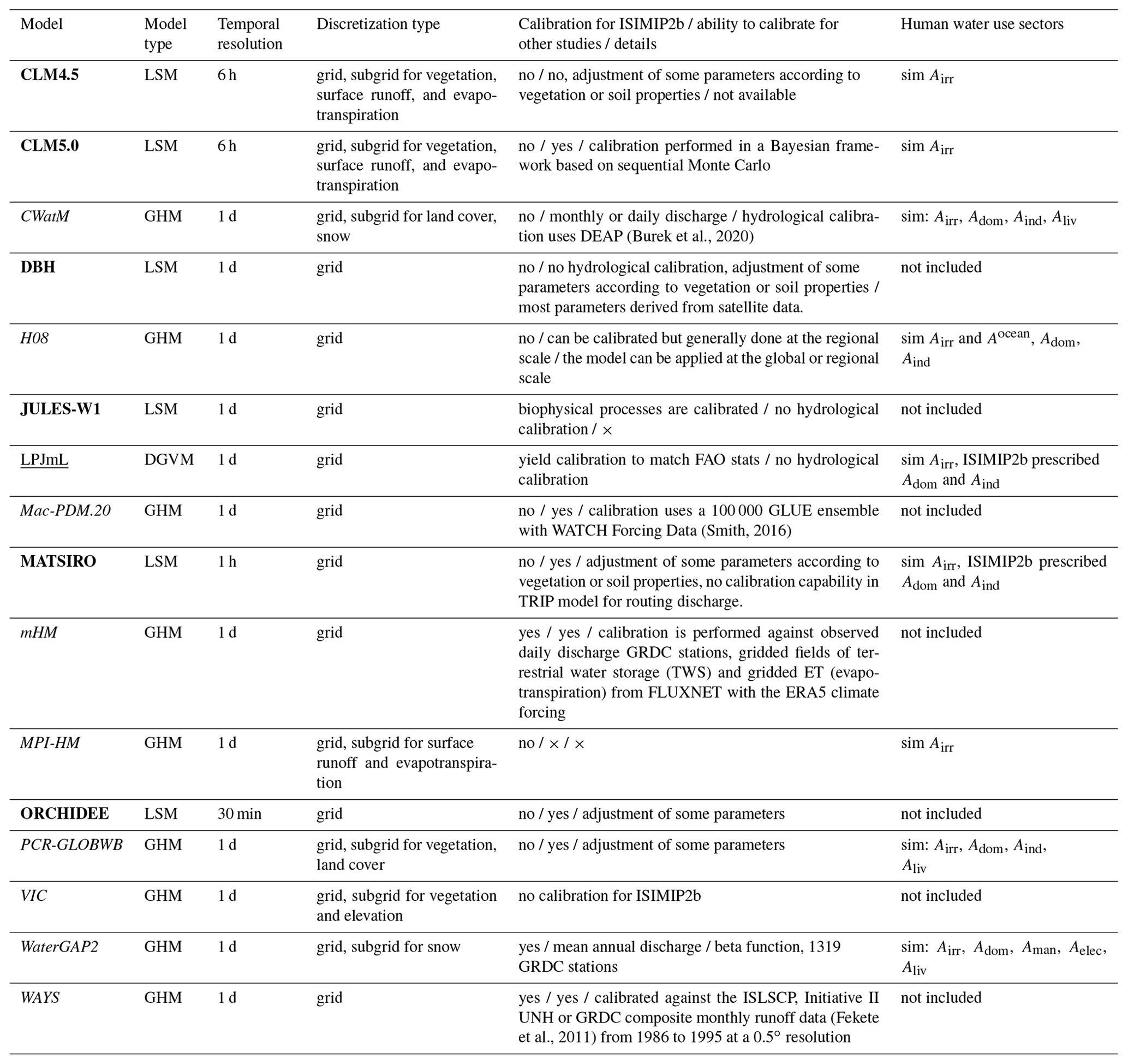
Comparison of global hydrologic model and land surface models
Global evaluation of runoff from 10 state-of-the-art hydrological models
In this paper, the authors compared six global hydrologic models (GHM) and four land surface models (LSM) to answer seven research questions:
- How do different models simulate runoff? -> differ remarkedly by models, underscoring the uncertainties in hydrologic modelling.
- How do different models perform in terms of long-term runoff trend? -> models share similar trends, although differ from observed trends.
- How do hydrologic models and land usrface models differ? -> GHM and LSM perform similarly in rain-dominated regions, but GHM is performing better in snow-dominated regions
- Are calibration and regionalization important or essential? -> calibrated model is able to obtain higher scores.
- What is the impact of forcing data? -> bias from precipitation propogated into model simulation
- How ensemble estimates improve the performance? -> ensemble mean perform slightly worse than the best calibrated model.
- Do all models show early bias in runoff timing in snow-dominated regions? -> early winter peak found in several models.
G-RUN ENSEMBLE: A Multi-Forcing Observation-Based Global Runoff Reanalysis
In this paper, the authos reconstructed global monthly runoff based on 21 different atmospheric forcings with a simple representation. They generated, evaluated, and published this dataset for public access. They ranked the different ensemble members in terms of long-term mean, interannual variability and percent change.

A WaterMIP project that conceptualizes 16 different Global Water Models, including six Earth System Model (ESM), nine Global Hydrologic Model (GHM), and one Global Vegetation Model. Models are set up for three period simulations - pre-industrial (1661-1860), historical (1861-2005), and future (2006-2099).
Developments in hydrometric network design: A review (Rev. Geophys.)
The number of hydrometric networks or gauges have been under a decline in a lot of countries in recent years.
Global Evaluation of Runoff Simulation From Climate, Hydrological and Land Surface Models
Our results show that (a) no model performs consistently better in estimating runoff from all aspects, and all models tend to perform better in more humid regions and non-cold areas; (b) the interannual runoff variability is well represented in ISIMIP2a and GLDAS models, and no model performs satisfactorily in capturing the annual runoff trend; (c) the runoff intra-annual cycle is reasonably captured by all models yet an overestimation of intra-annual variability and an early bias in peak flow timing are commonly found; and (d) model uncertainty leads to a larger uncertainty in runoff estimates than that induced by forcing uncertainty in ISIMIP2a, and model uncertainty in GLDAS is larger than that in ISIMIP2a.
Hydrologic Regionalization
Investigating regionalization techniques for large-scale hydrological modelling
In this paper, the authors presented unsupervised clustering and supervised clustering for hydrologic regionalization.
Process-based hydrologic modelling
Ivanov, V.Y., E.R. Vivoni, R.L. Bras, and D. Entekhabi (2004), Preserving high-resolution surface and rainfall data in operational-scale basin hydrology: a fully-distributed physically-based approach, J. Hydrol., 298, 80-111, doi: 10.1016/j.hrol.2004.03.041
In this paper, the authors exhaustively described the way to design a process-based modeling framework, and the design of meshes to preserve the variability of topographic inputs. They tested this operational model in three basins in Oklahoma, not only surface flow (discharge) is their concern, but other fluxes and states are included completely to introduce this model.
CREST family
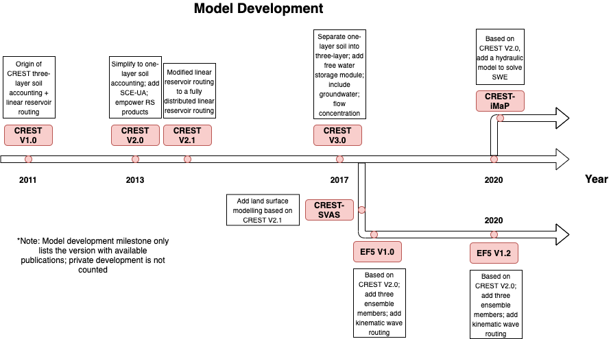
CREST 1.0
Jiahu Wang, Yang Hong, Li Li, Jonathan J. Gourley, Sadiq I. Khan, Koray K. Yilmaz, Robert F. Adler, Frederick S. Policelli, Shahid Habib, Daniel Irwn, Ashutosh S. Limaye, Tesfaye Korme & Lawrence Okello (2011) The coupled routing and excess storage (CREST) distributed hydrological model, Hydrological Sciences Journal, 56:1, 84-98, DOI: 10.1080/02626667.2010.543087
This paper detailed physical-based process (including water balance model components, sub-grid/downstream routing process).
The first paper introduced CRESTH model v1.0
CREST V1.6
Wu, H., R. F. Adler, Y. Hong, Y. Tian, and F. Policelli, 2012: Evaluation of Global Flood Detection Using Satellite-Based Rainfall and a Hydrologic Model. J. Hydrometeor., 13, 1268–1284, https://doi.org/10.1175/JHM-D-11-087.1.
CREST V1.6 applied to global flood detection
S. I. Khan et al., “Satellite Remote Sensing and Hydrologic Modeling for Flood Inundation Mapping in Lake Victoria Basin: Implications for Hydrologic Prediction in Ungauged Basins,” in IEEE Transactions on Geoscience and Remote Sensing, vol. 49, no. 1, pp. 85-95, Jan. 2011, doi: 10.1109/TGRS.2010.2057513.
Regional flood detection with multiple events.
In this paper, the authors firstly propose a framework by which the Global Forecast System and Global Ensemble Forecast System are incorporated to evaluate the detectability of flood events of the CREST model, as a function of lead time. This work is applied to a basin in Beijing, China at daily resolution.
CREST V2.0
(1) enhancement of the computation capability using parallel distribution techniques to make the model more efficient than the previous version (Wang et al., 2011); (2) model implementation with options of either spatially uniform, semi-distributed, or distributed parameter values; (3) automatic extraction of a-priori model parameter estimates from high-resolution land cover and soil texture data. The physically-based parameters, Ksat and WM, can be derived from land cover types and soil texture data based on a look-up table (Chow et al., 1988); (4) a modular design framework to accommodate research, development and system enhancements; and (5) inclusion of the optimization scheme SCE-UA (Duan et al., 1992, Duan et al., 1993) to enable automatic calibration of the CREST model parameters.
EF5-based CREST is originated here
EF5
In this paper, the authors introduced the capacity building of using EF5 to alleviate the flood damages in Africa
In this paper, the authors pre-tested the hydrologic performance of CREST/EF5 on the use of high-resolution MRMS data in the CONUS, to mark the transition from research to operation. Also the HRRR forecast data are used to forecast floods.
This paper firstly applies high-resolution MRMS data to the CREST/EF5 framework to forecast flash flood.
The Coupling of NSSL Warn-on-Forecast and FLASH Systems for Probabilistic Flash Flood Prediction
In this paper, the authors show a promising flood forecast framework based on Warn-on-Forecast concept, and integrated into the FLASH project. This is a follow-up study of 2018 Hydro-Met experiment but using ensemble to consider uncertainties.
CREST V2.1
Refining a Distributed Linear Reservoir Routing Method to Improve Performance of the CREST Model
Introduction:
The previous version of the CREST, using linear reservior routing, untruly produces discontinuous runoff, which tends to underestimate channel flow at the outlet point. Therefore, a fully distributed linear reservior routing model is proposed.
By definition, the fully integrated LRR means runoff produced at each trajectory cell is taken into account, instead of directly produced at desired point.
Three case studies are designed to verify the performance gain of the new routing scheme.
In this paper, the authors applied the CREST to simulate streamflow in Tibetan Plateau, in order to assess the newly developed Ensemble Multi-Satellite Precipitation Dataset using the Dynamic Bayesian Model Averaging scheme algorithm.
A highlight in this study is that the authors explained the errors with either suspection or physics in detail as well as proper citations.
In this paper, the authors adopted a systematic sensitivity analysis of the CREST V2.1, and surrogate modeling to optimize the model and alleviate the computational efforts.
Highlight:
They use surrogate model to represent ensemble members and indicate that the observation is contained in the box (25-75th percentile), which could be used as uncertainty estimation.
The CREST V2.1 was applied to predicting Ungaguged Basins in Chongqing, China for flood frequency analysis. It shows the constructed hydraulic structures i.e., dams, significantly limit the performance of transferred model performance.
CREST-SVAS
A framework to improve hyper-resolution hydrological simulation in snow-affected regions
Introduction:
The land surface model exhibits great uncertainty, especially the snow models, which in turn propagates errors into flow simulations.
In this paper, the authors extended the CREST model with a soil-vegetation-atmosphere layer (vegetation interception, snow accumulation, melting, and refreezing)
Improvements:
-
Three snow layers are added in addition to the CREST, to represent the snow melting, refreezing process.
-
Two ablation schemes (with or without canopy) were implemented.
-
A energy balance is included (only if snow is present)
A similar approach to CREST-SVAS, the authors apply the CREST to Tibetan Plateau, in conjunction of a snow-melting model in order to represent the cryosphere there.
The novelty of this paper is not only by introducing a coupled model, but the authors proposed a two-stage calibration, with the use of MODIS derived Snow Water Equivelent for calibrating snow-melting parameters and GRACE derived Total Water Storage (TWS) for calibrating storage. This surrogate approach has profound implication to ungauged basins.
iCRESTTRIGRS
iCRESTRIGRS: a coupled modeling system for cascading flood–landslide disaster forecasting
Coupled CREST with a landslide model to predict rainfall-induced landslide.
WRF-CREST-ADCIRC
In this paper, the authors coupled WRF-CREST-ADCIRC for the purpose of evacuation. The WRF generates ensemble atomospheric forcings for CREST and ADCIRC. Meanwhile, CREST provides upstream boundary conditions to ADCIRC to simulate the storm surges in the coastal region.
CREST V3.0
Kan, G.; Tang, G.; Yang, Y.; Hong, Y.; Li, J.; Ding, L.; He, X.; Liang, K.; He, L.; Li, Z.; Hu, Y.; Cui, Y. An Improved Coupled Routing and Excess Storage (CREST) Distributed Hydrological Model and Its Verification in Ganjiang River Basin, China. Water 2017, 9, 904.
The improvements of CREST V3.0 against V2.x are:
1). Separating the soil layer into three layers and considering tension water, soil moisture, and evapotranspiration computations like in the original version.
2). Adding a free water storage computation module with a free water distribution curve to describe the sub-grid variations of free water storage.
3). According to free water storage, separating runoff into three components, including overland flow, interflow, and ground water.
4). Improving the flow concentration module into a four-mechanism cell-to-cell routing, including overland flow, interflow, ground water, and river channel flow routings. Based on the arrival time of each upstream grid cell to its downstream outlet grid cell, the generated runoff is routed down along the flow concentration path generated according to the eight-flow-direction method.
Application
National Water Model
The performance or predictability of a typical hydrologic model with respect to infiltration excess runoff and saturation excess runoff.

Towards Real-Time Continental Scale Streamflow Simulation in Continuous and Discrete Space†
A continental simulation of US hourly streamflow by the NWM coupled with RAPID. They attributed problems with US streamflow simulation to snow melting dynamics, terrain routing, soils and groundwater which are spatially distinct over the US.
Groundwater Hydrology
The authors designed the experiment to investigate the long-distance groundwater flow, which reveals the indication of regional and large-scale hydrologic processes. They used the precipitation surplus versus recharge ratio to indicate how groundwater is divided and whether the groundwater in one basin is importer or exporter. This groundwater budget is highly relied on the topography, climate, and basin characteristics (geology).